
Martes, Marso 27, 2018
Bundok Makilig
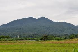
Bundok Makilig
Mount Makiling, or Mount Maquiling, is a dormant volcano located on the border of Laguna province and Batangas on the island of Luzon, Philippines. The mountain rises to an elevation of 1,090 m (3,580 ft) above mean sea level and is the highest feature of the Laguna Volcanic Field. The volcano has no recorded historic eruption but volcanism is still evident through geothermal features like mud spring and hot springs. South of the mountain is the Makiling-Banahaw Geothermal Plant. The Philippine Institute of Volcanology and Seismology (PHIVOLCS) classifies the volcano as potentially active.
Mount Makiling is a state-owned forest reserve administered by the University of the Philippines Los Baños. Prior its transfer to the university, the mountain was the first national park of the Philippines. Mount Makiling National Park was established on February 23, 1933 by Proclamation No. 552. However, it was decommissioned as a national park on June 20, 1963 by Republic Act no. 3523 when it was transferred to the University for use in forestry education and information.[2]
Now known as Mount Makiling Forest Reserve, it was declared an ASEAN Heritage Park in 2013
MAYON

MAYON
Mayon (Central Bicolano: Bulkan Mayon, Filipino: Bulkang Mayon), also known as Mayon Volcano or Mount Mayon, is an active stratovolcano in the province of Albay in Bicol Region, on the large island of Luzon in the Philippines. Renowned as the "perfect cone" because of its symmetricconical shape, the volcano with its surrounding landscape was declared a national park on July 20 of 1938, the first in the nation. It was reclassified a Natural Park and renamed as the Mayon Volcano Natural Park in 2000.[3]Local folklore refers to the volcano being named after the legendary princess-heroine Daragang Magayon (English: Beautiful Lady). Numerous festivals and rituals are associated with the volcano and its landscape.[4]The volcano is the centerpiece of the Albay Biosphere Reserve, declared by UNESCO in 2016
Bundok Banahaw

Bundok Banahaw
Mount Banahaw (alternative spelling: Banahao or Banájao) is an active volcano on Luzon in the Philippines. The three-peaked volcano complex is located between the provinces of Laguna and Quezon and is the tallest mountain in the CALABARZON region dominating the landscape for miles around.[4]
The mountain is considered by many as a "Holy mountain" and is popular among pilgrims along with mountain climbers. It is located in a protected areaknown as Mounts Banahaw–San Cristobal Protected Landscape covering 10,901 hectares (26,940 acres) of land
Mt. pinatubo

Mt. pinatubo
Mount Pinatubo (Sambal: Bakil nin Pinatubu; Kapampangan: Bunduk/Bulkan ning Pinatubu, Bunduk ning Apu Malyari; Pangasinan: Palandey/Bulkan na Pinatubu; Ilokano: Bantay Pinatubo; Tagalog: Bundok/Bulkang Pinatubo) is an active stratovolcano in the Zambales Mountains, located on the tripoint boundary of the Philippine provinces of Zambales, Tarlac and Pampanga, all in Central Luzon on the northern island of Luzon.[3][4] Its eruptive history was unknown to most before the pre-eruption volcanic activities of 1991, just before June. Pinatubo was heavily eroded, inconspicuous and obscured from view. It was covered with dense forests which supported a population of several thousand indigenous Aetas.
The volcano's Ultra Plinian eruption on June 15, 1991, produced the second-largest terrestrial eruption of the 20th century after the 1912 eruption of Novarupta in the Alaska Peninsula.[5] Complicating the eruption was the arrival of Typhoon Yunya (Diding), bringing a lethal messy mix of ash and rain to towns and cities surrounding the volcano. Predictions at the onset of the climactic eruption led to the evacuation of tens of thousands of people from the surrounding areas, saving many lives. Surrounding areas were severely damaged by pyroclastic surges, ash falls, and subsequently, by the flooding lahars caused by rainwater re-mobilizing earlier volcanic deposits. This caused extensive destruction to infrastructure and changed river systems for years after the eruption.[5][6]
The effects of the eruption were felt worldwide. It ejected roughly 10,000,000,000 tonnes (1.1×10¹⁰ short tons) or 10 km3 (2.4 cu mi) of magma, and 20,000,000 tonnes (22,000,000 short tons) of SO
2, bringing vast quantities of minerals and toxic metals to the surface environment. It injected more particulate into the stratosphere than any eruption since Krakatoa in 1883. Over the following months, the aerosols formed a global layer of sulfuric acid haze. Global temperatures dropped by about 0.5 °C (0.9 °F) in the years 1991–93,[7] and ozone depletion temporarily increased substantially
2, bringing vast quantities of minerals and toxic metals to the surface environment. It injected more particulate into the stratosphere than any eruption since Krakatoa in 1883. Over the following months, the aerosols formed a global layer of sulfuric acid haze. Global temperatures dropped by about 0.5 °C (0.9 °F) in the years 1991–93,[7] and ozone depletion temporarily increased substantially
Mount Apo

Mount Apo
Mount Apo (Cebuano: Bukid Apo) and (Filipino: Bundok Apo) is a large solfataric, potentially active stratovolcano in the island of Mindanao, Philippines. With an elevation of 2,954 metres (9,692 ft) above sea level, it is the highest mountain in the Philippine Archipelago and is located between Davao City and Davao del Sur province in Region XI and Cotabato provincein Region XII. The peak overlooks Davao City 45 kilometres (28 mi) to the northeast, Digos City 25 kilometres (16 mi) to the southeast, and Kidapawan City 20 kilometres (12 mi) to the west.
The first two attempts to reach Mt. Apo’s summit ended in failure: that of Jose Oyanguren (1852) and Señor Real (1870). The first recorded successful expedition was led by Don Joaquin Rajal in October 10, 1880. Prior to the climb, Rajal had to secure the permission of the Bagobochieftain, Datu Manig. It is said that the Datu demanded that human sacrifice be made to please the god Mandarangan. Fortunately, the datu agreed to waive this demand, and the climb commenced on October 6, 1880, succeeding five days later.[citation needed] Since then, numerous expeditions followed. These and more are described in colorful narrations by Fr. Miguel Bernad, S.J.
On May 9, 1936, Mount Apo was declared a national park by President Manuel L. Quezon.[7]
Mt. Apo is said to be named after a nobleman named Apong, who was killed while mediating the battle between two suitors of his daughter Saribu. Another proposed origin of the name is from the word Apo itself, which in Filipino tongues means “master” or “grandchild”.[citation needed]
In late March–April 2016, due to the extreme effects of El Niño, massive patches of forest fires and bushfires appeared on the slopes of the mountain, causing hikers on the mountain to halt their ascent. Tourism in the region was threatened due to a massive haze engulfing the slopes of the mountain.
Mag-subscribe sa:
Mga Komento (Atom)